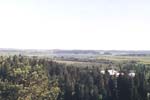
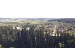
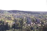
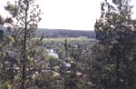
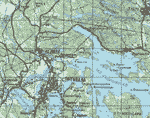
in Russian in Russian Suomeksi Suomeksi

location

Heliulia is a town-type village; it is an administrative unit of the Sortavala area of the republic of Karelia. It is located on the Tohma river, which flows from north-west from the Finnish side of the border and merges the Heliulianjoki river two kilometers down the river from the village; and another kilometer down the river it merges the northernmost part of the Ladoga lake (Ladoga stretches from south to north for 207 km. and its widest part at 61 degress northern latitude is 130 km. The area of the lake is over 18 000 km.2 and the volume of water in it is approximately 900 km.3). Heliulia is located on a wide Heliulia plain, which is limited by forrests and hills and by the vast waters of Karmalanjarvi. The village borders with such other villages as Miulliukiulia, Telmana, Aniala, Rautakangas.

larger panorama larger panorama larger panorama larger panorama
The fields of the Heliulia plain; far to the left is the Karmalanyarvi lake
The older part of the village
The central part of the village
A glance at the river

The village is located on the Sortavala-Petrozavodsk and Sortavala-Vartsila (to Finland) road, 5 km. away from the city of Sortavala. The border with Finland in the Vartsila village is about 60 km. away. Saint Petersburg is 260 kilometers away, the city of Priozersk is halfway on the road to St. Petersburg. The city of Petrozavodsk is 280 km away. You can enter the village by railroad (the train #249/250 to Kostomuksha from St. Petersburg - a 6-hour trip or from Petrozavodsk - that would take 8 hours) - straight to the Heliulia station; you can enter by river; you can fly in by an airplane or a helicopter - straight to the airport; or drive in by car from four different directions - from Sortavala (You can get to the village by bus #1); from the Vartsila/Petrozavodsk direction; from the Anjala village (the "Mebelschik" summerhouse villages), but you can only get there from the Telman village; and by an old road from Kaalamo and Zaoziorniy.

Helyla area map
Helyla area map
The territory of Heliulia has earlier belonged to Finland for quite some time. Most of the topographic objects are named in Karelian/Finnish, although many have acquired Russian or Soviet toponyms. There are the "Third Lake", the "Borderline forrest", the "Airport", "Beyond The River", Telman... Present-time village is located a bit away from the original location of Heliulia, which was the merger of the Tohma and the Heliulianyoki rivers (it is now the Heliulia hamlet, also named after Ernst Telman, former Central Quarters of the "Sortavalskiy" farm).

Approximate geographical coordinates of the village are 61° 48' northern latitude and 30° 39' eastern longitude.

back